Mill Force Waterfall Bowes
If you're visiting Bowes Castle, there's a good chance you'll be closer to Mill Force than you realise.
This small waterfall sits beside the River Greta just below Bowes village and is only a few minutes walk from Gilmonby Bridge. It's not the biggest waterfall in Teesdale, but what it lacks in height it makes up for in history.
For centuries this stretch of the river helped power Bowes Mill, a water-powered corn mill that stood beside the Greta. The mill has long since disappeared, but the waterfall remains, along with pieces of old stonework and iron fittings that still hint at the site's past.
Today it's a peaceful place to stop for a few minutes, listen to the river and explore a lesser-known part of Bowes' history.
Quick Facts
Location: Bowes, County Durham
Postcode: DL12 9LG
Watercourse: River Greta
Walk Distance: Around 0.5 mile return
Time: 10–15 minutes
Difficulty: Easy
Terrain: Woodland paths and uneven riverside ground
Parking: Free parking at Bowes & Gilmonby Village Hall
Dog Friendly: Yes
Map: OS Explorer OL31 – North Pennines

Parking and Directions
The easiest way to visit Mill Force is from the free car park at Bowes & Gilmonby Village Hall.
From the car park, turn left and walk towards Gilmonby Bridge.
Just before reaching the bridge, look for an opening on the right-hand side. Head through the opening and join the well-marked riverside path beside the River Greta.
The route is short, straightforward and easy to follow. Within a few minutes you'll reach Mill Force Waterfall.
Although the walk is brief, it feels surprisingly peaceful. The woodland quickly screens out the surrounding roads and buildings, leaving only the sound of the river flowing through the valley.
Good footwear is recommended, particularly after wet weather when parts of the path can become muddy.

A Small Waterfall with a Big Story
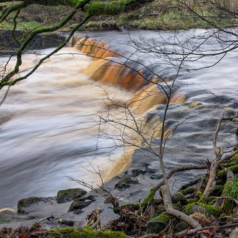
Mill Force is not one of Teesdale's tallest waterfalls, but it is one of the most interesting.
The waterfall spills over the remains of an old weir on the River Greta, creating a broad curtain of water that changes character throughout the year. After heavy rain it becomes powerful and noisy, while during drier periods the water flows more gently across the stone edge.
What makes Mill Force different from many other waterfalls is the history around it. The waterfall, weir and surviving remains of Bowes Mill all sit together in one small area, allowing you to see how the river once powered daily life in the village.
Today it is a quiet place to stop for a few minutes beside the water and discover a piece of Bowes's forgotten history.
The Mill Behind Mill Force
The waterfall takes its name from Bowes Mill, which once stood beside the River Greta just above the falls.
Long before it became the quiet woodland spot we see today, the power of the River Greta was being used here to grind grain. A water mill is recorded at Bowes as early as 1280, and later medieval records show that milling continued here for hundreds of years afterwards.
By the late Victorian period the mill was still an important part of village life. In 1890, Bowes Mill was employing both a corn miller and a foreman miller, showing that grain was still being brought here to be processed using the power of the Greta.
The mill continued into the early twentieth century and was still being mentioned in local newspapers in 1908. At some point during the years that followed, the buildings disappeared and the site gradually returned to nature. Exactly when the mill closed is unclear, but the waterfall, weir and fragments of masonry beside the river still reveal where it once stood.
If you look carefully around the site today, you can still spot surviving stonework hidden amongst the trees. Old masonry blocks lie beside the path, sections of the former mill structure remain beside the river, and pieces of ironwork can still be found where the machinery once operated.
Most visitors come to see the waterfall, but Mill Force is really two places in one. It is a beautiful stretch of the River Greta, and it is also one of the few surviving reminders of a mill that served Bowes for hundreds of years.
What You'll See
Mill Force Waterfall
The waterfall itself remains the centrepiece of the location, with water flowing over the old weir before continuing downstream through the wooded Greta valley.
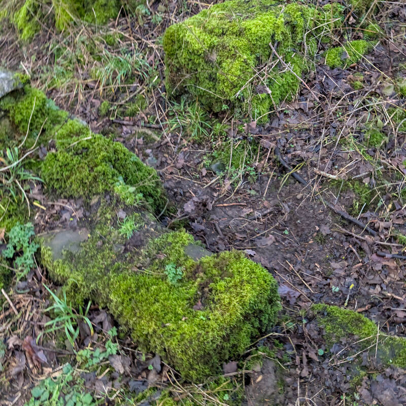
Old Mill Remains
Look carefully around the waterfall and riverbank and you'll spot surviving stonework linked to the former mill site. These weathered remains are all that survives of a place that once formed part of everyday village life.
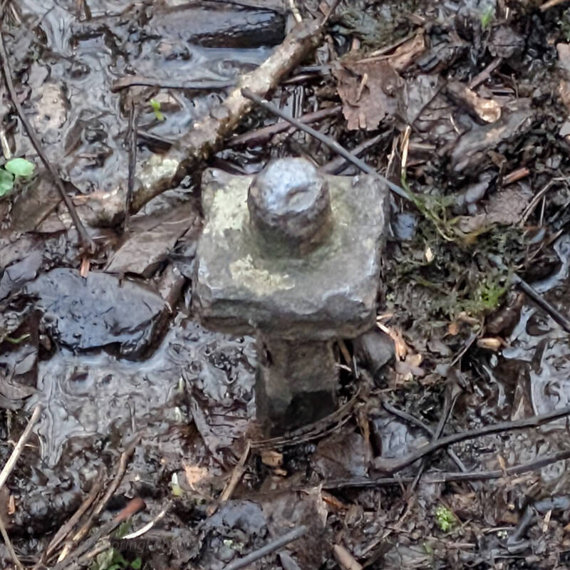
Historic Ironwork
Hidden among the stones are pieces of old ironwork connected with the mill. They are easy to miss at first glance but provide a fascinating link to the site's industrial past.
Why It Is Called Mill Force
The name tells the story of the site.
The word "Force" comes from the Old Norse language and simply means waterfall. The same word appears throughout northern England at places such as High Force, Low Force and Cauldron Snout.
The "Mill" part refers to Bowes Mill, the historic corn mill that once stood beside the River Greta.
Together they create a name that perfectly describes the place: the waterfall that powered the mill.
Perfect for a Quick Nature Escape
One of the best things about Mill Force is how little effort it takes to reach.
You don't need to set aside half a day, carry specialist equipment or tackle a long hike. Within minutes of leaving the village hall car park you can be standing beside flowing water surrounded by woodland.
Sometimes that is all you need.
A short walk, a quiet river and ten minutes away from the distractions of everyday life can make a surprising difference.
Want to Explore More?
If you'd like to see more of Bowes, our Bowes Castle and Mill Force Walk combines the waterfall with Bowes Castle, open countryside, woodland paths, Gilmonby Bridge and the site of St Farmin's Well.
At just 1.3 miles, it's an easy circular walk that brings together some of the village's most interesting history, scenery and riverside views.
Looking for another easy walk? Try our Barnard Castle Circular Walk, a 2.5 mile route that follows the River Tees and offers some of the best riverside scenery in the area.
For a peaceful village walk, our Romaldkirk Circular Walk takes you past Low Garth Farm and the fascinating Fairy Cupboards, one of Teesdale's most unusual geological features.
If you'd like something a little longer, the Cotherstone Moor Walk is approximately 6.5 miles and explores a quieter side of Teesdale, passing the abandoned East Loups and West Loups farmsteads along with prehistoric rock art hidden amongst the moorland landscape.
Wherever you choose to explore next, we hope you enjoy discovering a little more of what makes Teesdale such a special place.