Cow Green Mine History Walk
This Cow Green Mine History Walk is a fascinating out and back route across the open moors above Cow Green Reservoir, following a clear track through one of the most historic mining landscapes in Upper Teesdale. Starting from Cow Green Reservoir Car Park, the walk takes in the remains of West Cow Green Mine, Dubbysike Mine and Greenhurth Mine, with wide reservoir views, old spoil heaps, ruined buildings and the line of the former wagonway all helping to bring the area’s industrial past back to life.
It is a walk that rewards curiosity rather than speed. For much of the route, navigation is simple because you are following the main track, but what surrounds you is far from ordinary. Mine entrances, exposed workings, ruined structures and the remains of a once busy upland industry sit within a landscape that now feels quiet, remote and almost forgotten. If you enjoy open moorland, mining history and walks where the past still feels close to the surface, this is one that stays with you.
Quick facts
Distance: 5.4 miles
Route type: Out and back
Elevation gain: Moderate, with some ups and downs along the track
Terrain: Wide moorland track, rough mining ground near the workings, uneven sections
Difficulty: Moderate
Dog friendly: Yes, with care around livestock, mine remains and exposed ground
Pushchair friendly: A sturdy off road pushchair may manage most of the main track, but rougher sections near the workings are not ideal
OS map: Explorer OL31 North Pennines
Digital route: View the full route on Hiiker

Parking and access
Parking for this walk is at Cow Green Reservoir Car Park, DL12 0HX, which makes an easy and practical starting point for exploring the mining landscape. One of the nice things about this route is that the history begins almost straight away, with the remains of West Cow Green Mine close to the car park before you even properly head out along the track.
The walk mostly follows a clear moorland track, so the route is fairly easy to follow in good conditions. Even so, this is a high and exposed part of Upper Teesdale where the weather can change very quickly. Wind, mist and rain can all make the walk feel more serious, so sturdy footwear, waterproofs and sensible clothing are strongly recommended.
This route passes through a historic mining landscape with exposed shafts, mine entrances, spoil heaps and old ruined workings. Please take great care, especially if walking with children or dogs. Parts of Green Hurth are a scheduled monument, and the waterwheel structure is Grade II listed, so nothing should be touched, moved or climbed on.

Route description
From Cow Green Reservoir Car Park, begin by following the main track out North West across the open moor. Almost immediately, the landscape hints at its industrial past. Near the start are the remains associated with West Cow Green Mine, a quieter and less obvious site than some of the others on the route, but still an important part of the wider story. It is worth slowing down here and taking a proper look, as it sets the tone for the walk ahead.
Continue along the track as the moor begins to open out around you. This is a route that feels remote without being difficult to navigate, as for most of the walk you simply keep following the main track forward. Before long, you reach the remains of Dubbysike Mine. The ruined building here is one of the most striking features on the route, standing as a reminder of how much activity once took place in what now feels like a quiet and empty landscape.
Keep going along the track and you will eventually come to Greenhurth Mine Buildings on your right. This is one of the most important and atmospheric parts of the walk. From here, bear left and follow the line of the old wagonway down towards the lower workings. This descent needs care, as the ground becomes rougher and the remains more exposed. There are visible shafts, mine entrances, loose stone and unstable areas, so it is important to move carefully and avoid getting too close to edges or openings.
Further down, you reach the most dramatic remains of the site, including the level entrance and the surviving stone structure linked to the old waterwheel, now protected as a listed structure. These features give a strong sense of how organised and extensive mining here once was. Even now, with the moorland slowly reclaiming the ground, the scale of work carried out here is still easy to feel.
When you are ready, retrace your steps back along the old wagonway to the main track, then return the same way to the car park. The return walk gives you another chance to appreciate the wide views and the sheer openness of the landscape. This is not a walk to hurry through. It is one to take slowly, looking around properly and imagining how busy these quiet hills once were.
West Cow Green Mine
West Cow Green Mine is the first historic feature on the walk and helps show that this industrial story begins almost at the car park. Although the remains here are more subtle than at Green Hurth, the site still gives an early glimpse into the wider mining landscape that once stretched across this part of Upper Teesdale.
It is easy to pass by without realising what you are looking at, but that is part of what makes this walk so interesting. The history here is not staged or signposted. It sits quietly in the ground, waiting to be noticed.
Dubbysike Mine
Dubbysike Mine is one of the most visually memorable stops on the route. The ruined stone building stands against a wide open backdrop of moorland and reservoir, making it feel both isolated and powerful. It is a place where you can pause and imagine the effort it once took to work in such an exposed upland setting.
Although much quieter now, Dubbysike still holds a strong presence in the landscape. Its ruined structure helps connect the walk to the real working life of the moor, rather than just its scenery.
Green Hurth Mine
Green Hurth Mine is the main historic focus of the walk and one of the most important surviving mining sites in the Cow Green area. The ruined buildings, level entrance, exposed workings and line of the wagonway all help show the scale of activity that once took place here.
This is also the part of the route where extra care is needed. The remains are fragile, historically important and in places dangerous, with exposed shafts and unstable ground. Viewed respectfully from the outside, though, it is one of the most fascinating mining locations in Upper Teesdale.
A landscape shaped by mining
What makes this walk so special is not just the individual mine sites, but the way the whole landscape still carries the marks of industry. Spoil heaps, altered slopes, old entrances and rough scars in the ground appear again and again along the route. Some are obvious, while others only reveal themselves when you stop and look properly.
Once you start noticing these details, the moor feels different. What at first seems like empty upland begins to show itself as a place shaped by labour, risk and long forgotten routines. This is a walk where history is not confined to one building or one viewpoint. It is spread right across the ground beneath your feet.
Things you will see
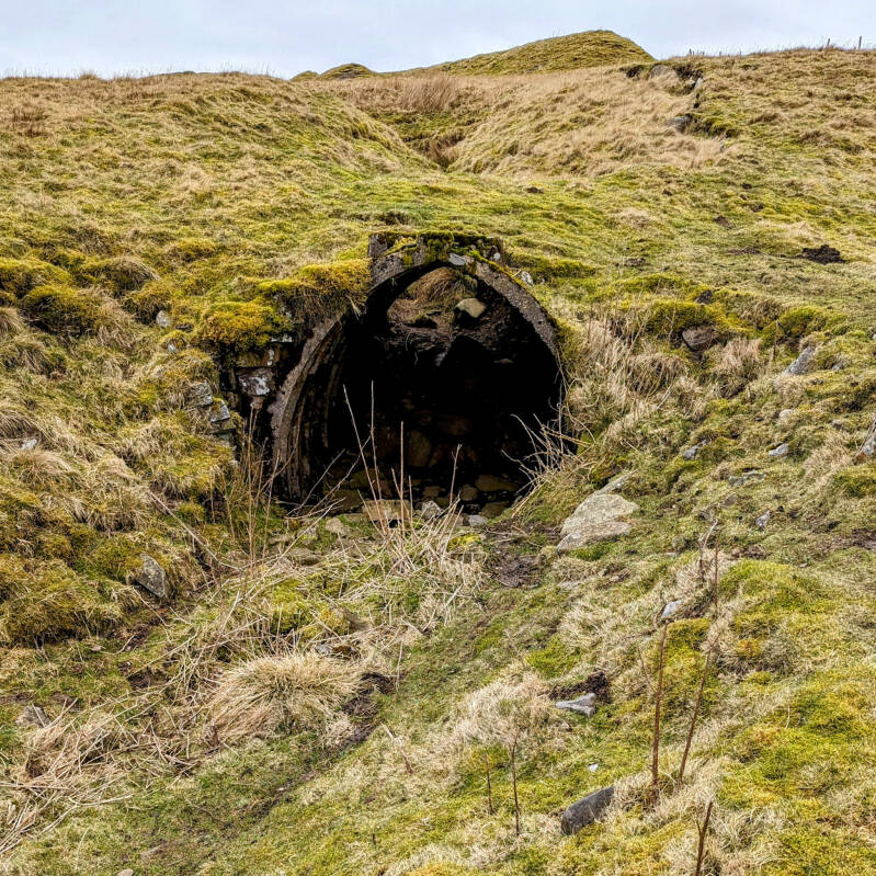
West Cow Green Mine Entrance
Close to the start of the walk, this old entrance is easy to miss if you do not know it is there. It quietly introduces the industrial history of the area almost from the moment you leave the car park.

Track to Dubbysike Mine
For much of the walk, the route is easy to follow thanks to the broad moorland track. It makes this a good option for walkers who want open, exposed scenery without difficult navigation.
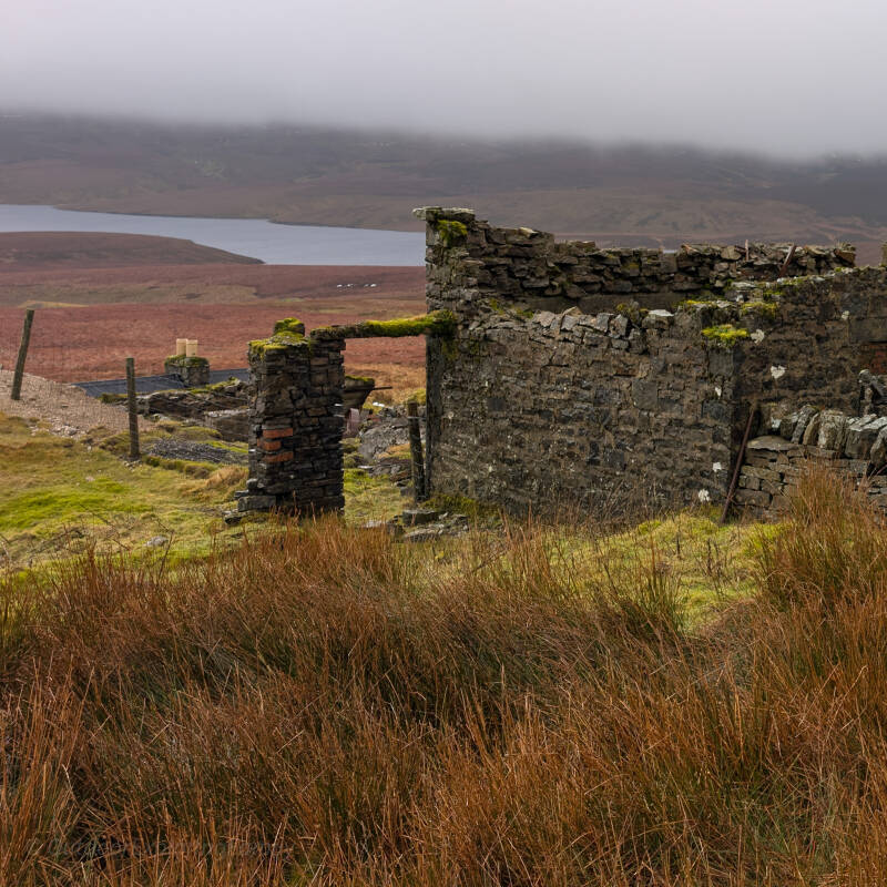
Dubbysike Mine Building
A ruined stone building standing high above the moor, with Cow Green Reservoir in the background. It is one of the strongest visual reminders that this quiet landscape was once full of industry and hard physical work.

Old Wagonway Track
Following the old wagonway adds another layer of history to the walk. It is more than just a path, as it once formed part of the working route through this mining landscape.

Green Hurth Mine Workings
Seen from above, the workings at Green Hurth spread across the hillside in spoil heaps, disturbed ground and old industrial scars. This wider view helps show just how extensive the site once was.

Green Hurth Level Entrance
The stone lined level entrance at Green Hurth is one of the most striking features on the walk. Built with skill and care, it gives a real sense of the scale and seriousness of mining in this remote place.
Safety and access information
This walk passes through a historic mining landscape with exposed shafts, mine entrances, spoil heaps and ruined buildings. These features are fragile and can also be dangerous, so mine workings should never be entered and ruined structures should not be climbed on.
Parts of the route pass through or beside historically protected remains, including a scheduled monument and a Grade II listed structure at Green Hurth. Please leave everything exactly as you find it and enjoy the site with care and respect.
The route is mostly easy to follow, but this is still open moorland where conditions can change quickly. Ground can be muddy, rough or uneven, especially near the mine workings. Suitable footwear and weather appropriate clothing are strongly recommended.
A Moment of Calm
This is not a walk to rush.
There is a strange stillness to Cow Green. The moor feels wide and open, the reservoir sits quietly below, and the old ruins seem to hold onto their own silence. Even in a landscape shaped by hard labour and industry, there is now a calm that settles over everything.
Take your time here. Pause at the ruins, look out across the moor, and imagine what this place once sounded like when men, tools, carts and waterwheels brought movement and noise to what now feels remote and empty.
About This Walk
This walk was explored and recorded on foot by Outdoor Exploring Family as part of our ongoing work documenting Teesdale’s walks, mining history and quieter landscapes.
The route is mainly an out and back walk along the track from Cow Green Reservoir Car Park, with a detour down the old wagonway to the lower Green Hurth workings. The digital route shows the exact path followed, but we always recommend carrying a paper map and using your own judgement on the ground.
This walk forms part of Discover Teesdale, our growing guide to the walks, history, waterfalls and peaceful places that make this part of the North Pennines so special.