Dubbysike Mine Cow Green
High on the open moorland above Cow Green Reservoir, Dubbysike Mine sits quietly among the grass and stone, its remains scattered across the hillside.
At first glance, it can feel easy to miss. There are no signs, no fences guiding you in, just broken walls, rusting metal, and the subtle marks of industry left behind.
But once you begin to look more closely, the scale of the place starts to reveal itself.
Dubbysike Mine formed part of the wider Cow Green mining area in Upper Teesdale, where generations of miners worked the land for lead and later barytes. Today, what remains has not been restored or rebuilt, but left as it was, slowly blending back into the landscape.
It is this honesty that gives the place its quiet strength.

Location and Access
Dubbysike Mine lies approximately 1.2 miles north west of Cow Green Reservoir car park, postcode DL12 0HX.
From the car park, a well defined track leads out across the moor towards Herdship Fell. The route is clear and steady, passing the remains of West Cow Green Mine before continuing towards Dubbysike.
The track itself passes directly through the main group of mine buildings. These structures are fenced off, as they are unstable, but can still be clearly seen from the path.
The mine extends beyond this central area, with additional remains spread across the surrounding hillside.
Although the route is straightforward, the area is fully exposed to the weather, and conditions can change quickly even on a calm day.
History of Dubbysike Mine
Dubbysike Mine formed part of the Cow Green group of mines within the North Pennines orefield, an area with a long history of lead mining.
Early workings focused on extracting galena, the main ore of lead, from mineral veins running through limestone and sandstone beneath the moor. Over time, as lead production declined in profitability, barytes became the primary material extracted.
Barytes, or barium sulphate, was widely used in industrial processes including paper making, paint production, and chemical manufacture, and became increasingly important during the later phases of mining here.
The site developed into a complex operation, with evidence of surface opencuts and hushes, underground levels, crosscut adits, and multiple shafts sunk into the hillside.
Further development took place during the twentieth century, including new shafts and adits driven during both World War periods. The mine remained under lease into the later twentieth century, although active working had ceased by the mid 1900s.
What Remains Today
What makes Dubbysike Mine particularly striking is how much can still be seen.
Rather than being cleared or reclaimed, the site has been left largely undisturbed, allowing the structure of the mine to remain visible across the landscape. The images below show some of the main remains near the track, but these are only part of the site. Further down the page, you will find additional images of the lower workings, including the hidden levels and waterwheel remains that many visitors never see.


The Buildings Near the Track
One of the first features visible when approaching the site is the stone building beside the track.
Although it sits among the mining remains, this is not an original mine building. It is a later shooting hut, used for grouse shooting on the surrounding moor.
Just above and behind it, the shooting butts can still be seen built into the hillside, linking the building to its later use.
This can give the impression that the mine is smaller than it really is, but in reality, these structures represent only a small part of what survives here.
Collapsed Stone Structures
The remains of stone buildings still stand on the hillside, their walls partially intact despite years of exposure to wind and weather. These structures would have been used for storage, shelter, or processing, and give a clear sense of the scale of activity that once took place here.
Ore Processing Remains
Fragments of rusting machinery remain among the stonework, including parts of ore crushing and handling equipment.
These remains show how material extracted from the ground would have been processed before being transported away from the site.
More Than What You First See
From the main track, it can feel as though you have seen the site.
Stone walls, machinery, and the shooting hut sit clearly in view, giving an impression of the mine’s layout.
But this is only part of the picture.
Much of Dubbysike Mine extends beyond what is immediately visible, with additional workings spread across the hillside and down towards the River Tees.
The Hidden Lower Workings
Historic mapping of the area reveals a much larger and more complex site than first appears.
Further down the slope towards the River Tees, just above Low Crag Pool, there are remains linked to earlier workings.
These include the position of a water wheel system, likely used to power mining operations, along with the entrance to Muse’s Level.
Across the hillside, the Dubbysike hush cuts through the ground, marking where water was once used to expose mineral veins.
To the opposite side, the Dubbysike Level entrance can be identified, showing how the mine extended into the hillside through underground workings.
Taken together, these features show that what is visible from the track is only part of a much wider mining landscape.
Hushes in the Landscape
The surrounding slopes show clear signs of hushing, an early mining technique used to expose mineral veins.
Water was collected and then released in controlled bursts, washing away soil and surface rock to reveal what lay beneath.
At Dubbysike, these hushes form deep, eroded channels running through the hillside, still clearly visible today.
The Lower Workings by the Tees
Beyond the main track and the more obvious remains, Dubbysike Mine continues further down the hillside towards the River Tees, in an area many people never reach.
Following the slope down towards Borderonmere Sike, near where the River Tees begins to widen into the upper end of Cow Green Reservoir, the landscape quietly changes. The ground becomes softer underfoot, wetter in places, and far less defined.
This is where some of the most hidden parts of the mine can be found.
Across the river from here, the cascades of Force Burn can sometimes be seen after rainfall, adding another layer to the sense of water shaping this landscape.
Dubbysike Level and Muse’s Level
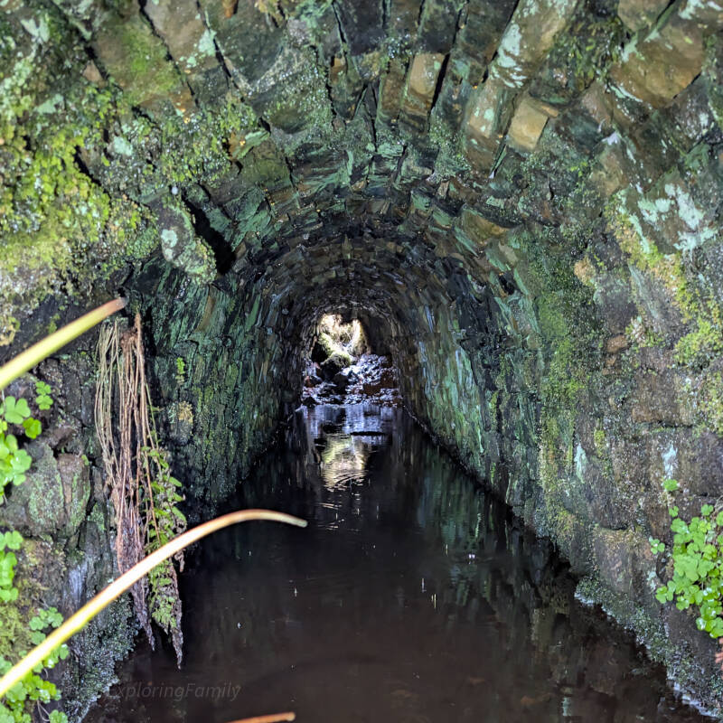
Set into the hillside, and easy to walk past without noticing, are the entrances to Dubbysike Level and Muse’s Level.
These low, stone-lined openings disappear into the ground, their entrances partially hidden by grass, moss, and the natural shape of the slope. Without knowing they are there, it would be easy to miss them entirely.
Inside, the levels still carry water, reflecting the stonework and giving a glimpse into the underground workings that once extended deep beneath the moor.
These were not just small openings, but part of a wider underground network, driven into the hillside to follow mineral veins and drain the workings.
Subtle Signs of Industry
Scattered around this lower area are smaller details that hint at the activity that once took place here.
Low spoil heaps sit quietly among the grass. Pieces of rusting metal lie half hidden in the ground. Nothing stands out at first glance, but taken together, they reveal the scale of what once existed here.
This is not a single site, but a landscape of workings.
The Waterwheel Remains
To the south west of Muse’s Level, the remains of a waterwheel system can still be found.
Here, stonework forms the outline of a wheel pit, with sections of wall still standing and the shape of the structure clearly visible. Within the remains, fragments of old mechanisms can still be seen, including chain links and iron fittings that once formed part of the working system.
This waterwheel would have been used to power parts of the mine, likely assisting with drainage or ore processing, using water drawn from the surrounding becks.
Today, it sits quietly in the grass, one of the most overlooked features of the entire site.


A Different Kind of Ground
Unlike the main track, this lower area is not straightforward to walk.
The ground is uneven and often boggy, with soft patches, hidden dips, and wet ground especially after rain. Care is needed when exploring, both for footing and for the hidden remains that sit just below the surface.
It is not a place most visitors reach, but for those who do, it reveals a very different side of Dubbysike Mine.
More Than One Mine
Standing down here, away from the track, it becomes clear that Dubbysike is not just a single cluster of buildings, but a much wider mining landscape.
From the visible remains near the path to the hidden levels, hushes, shafts, and water-powered systems below, the site stretches far beyond what first appears.
It is this contrast that makes Dubbysike so fascinating.
Most people see the surface.
Very few see the whole.
Shafts and Underground Access
There are numerous shafts across the site, some clearly visible and others hidden within grass and spoil.
These shafts provided access to deeper workings and are a reminder of both the scale of the mine and the risks faced by those who worked here.
Transport and the Cow Green Railway
In the early twentieth century, a narrow gauge railway was constructed across the moor to transport barytes from Dubbysike Mine towards Cow Green and connecting processing areas.
Wagons were hauled by horses along this route, following a track that still forms part of the path used today.
This means the route from Cow Green is not just a walking path, but part of a former industrial transport system that once linked the mines across the moor.
A Remote Working Life
Working at Dubbysike would have been demanding and often harsh.
The mine sits high on exposed moorland, where weather conditions could change quickly and access was difficult compared to lower valley sites.
Daily life revolved around the needs of the mine, with long hours and physically demanding work carried out in a remote environment.
Despite this, the site remained active through multiple phases of development, adapting to changing demand and different minerals over time.
Safety and Respect
Dubbysike Mine is an unmaintained historic site.
Shafts may be concealed, stone structures are unstable, and metal remains can be sharp or corroded. Care should always be taken when exploring, and it is best to observe rather than approach any potentially dangerous features.
A Moment in the Landscape
There is a stillness here that is hard to ignore.
Where there was once noise, movement, and industry, there is now only wind across the moor and the quiet presence of what remains.
Standing among the ruins, it becomes clear how much effort it took to work in a place like this, and how quickly nature reclaims it once that work ends.
Dubbysike Mine does not try to explain itself.
It simply remains, in stone and silence, for those who take the time to notice.