How Barnard Castle Grew
It is easy to assume that Barnard Castle began when somebody chose the cliff above the Tees and built a fortress there. The real story starts earlier, on the opposite side of the river.
By the time the Domesday Book was compiled in 1086, Startforth was already a settled place. The entry records six ploughlands and a church, so this was not simply a name attached to empty land. People were farming, worshipping and living beside an established crossing of the Tees before the castle or the town of Barnard Castle existed.
The fortress came next, followed by the streets, market, bridge, churches, mills and houses that grew around it. Much later came the Witham, the railway, Barnard Castle School and the Bowes Museum. None of these developments wiped away everything that had gone before. They were fitted around older roads and boundaries, which is why so much of the town’s history can still be understood simply by walking through it.
Before the castle: Startforth, the road and the ford
The earliest firm date in the story is 1086, when Startforth was recorded in the Domesday Book. Its estate included six ploughlands and a church, and had been held before the Norman Conquest by Thor and Thorfin of Ravensworth. By 1086, Count Alan of Brittany was the tenant-in-chief, with Bodin and Enisant Musard named as lords.
The entry describes the estate as partly waste. That wording can sound as though the whole place had been abandoned, but that is not what the record says. Agricultural land and a church were still listed, so there was clearly an established community here. The damage may belong to the disruption and destruction that followed the Norman Conquest in northern England.
No surviving house in Startforth can be identified as a Domesday building, and the church recorded in 1086 was not the present church. Early houses, barns and places of worship were repeatedly repaired and replaced. What the record proves is that Startforth was already a functioning settlement with its own church before the Balliols built across the river.
The old name is often rendered as Stradford or Stretford and is generally linked with a road or street beside a ford. That fits its position perfectly. Long before County Bridge, people and animals were coming down towards the Tees and crossing through the water. The exact course of that early route through modern Barnard Castle has not been proved, but the crossing explains why the castle was placed where it was.
The order is worth remembering: first came the route and ford, then the settlement and church at Startforth. The castle and the town that took its name followed afterwards.
The Balliols build above the Tees
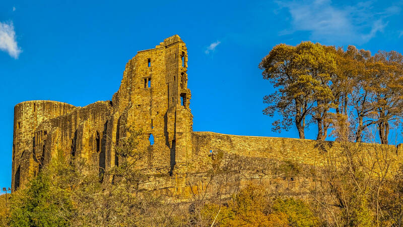
The first castle was probably established by Guy de Balliol soon after 1093. It did not yet resemble the great stone ruin overlooking the town today. The earliest stronghold was largely built from earth and timber, with banks and ditches adding to the natural protection provided by the cliffs.
Its position was carefully chosen. From the high ground, the Balliols could watch the river crossing and control movement through this part of the Tees valley. The castle was not simply somewhere to defend during an attack; it was also the centre from which a large estate could be managed.
Guy died in 1133 and was succeeded by his nephew Bernard de Balliol. Bernard is the man who gave the place its lasting name. It became known as Castrum Bernardi—Bernard’s Castle and from that came Barnard Castle.
During the 12th century, the fortress was enlarged and rebuilt in stone. Much of the Inner Ward was strengthened between about 1125 and 1140, while further walls, wards, gateways, buildings and the castle chapel of St Margaret followed during the middle decades of the century. Between roughly 1170 and 1185, a new hall, Great Chamber and additional towers made it a far more comfortable home as well as a formidable stronghold. The Round Tower followed around 1200, and much of what survives today belongs to these 12th- and early-13th-century building phases.
A castle of that size could not exist in isolation. Soldiers, servants, builders, craftsmen and traders were needed, along with a regular supply of food, livestock, timber, tools and clothing. People gathered beside the walls because the castle created work, trade and protection. Over time, that settlement became a town.
How the medieval town took shape
By about 1175, Barnard Castle was recognised as a borough. It was no longer merely a few houses clustered beside a fortress, but an organised trading settlement with streets, rights and carefully divided property.
The main holdings were long, narrow strips known as burgage plots. A house, shop or workshop stood at the street frontage, while the land behind could contain a yard, stable, garden, store, shed or another small dwelling. The narrow frontage allowed many traders and householders to face the busiest streets.
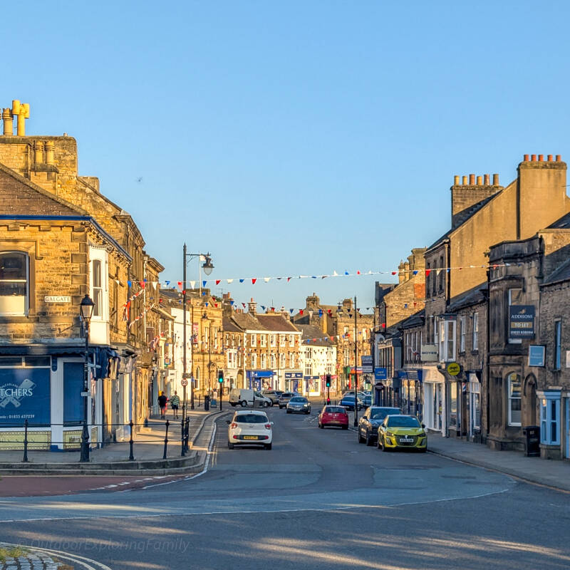
Those medieval divisions still explain a great deal about Barnard Castle. Many buildings in Galgate, Horse Market, Market Place, Newgate, The Bank and Thorngate look Georgian or Victorian from the front, yet the plots behind them remain long and narrow. Houses were rebuilt, shopfronts were added and neighbouring properties were sometimes joined together, but the older boundaries often stayed where they were.
Galgate may preserve the earliest settlement line on the Barnard Castle side of the river. It is noticeably broader than The Bank or Thorngate, and Durham County Council’s study of the town suggests that it may once have formed a two-row settlement, with buildings facing one another across a wide open area. That central space could have worked as a green, gathering place or somewhere to hold animals.
It is a strong interpretation rather than a proven construction date. Archaeology has not yet shown that houses stood there before Bernard de Balliol’s borough was laid out. Galgate may pre-date the planned town, or it may belong to its earliest stage.
Older forms such as Gallow Gate and Gallowsgate suggest a connection with the town gallows or a road leading towards them. In northern street names, “gate” often meant a road or street rather than an opening through a wall. The tradition that executions took place around Cripple Hill may preserve a real local memory, but the exact gallows site has not been archaeologically confirmed.
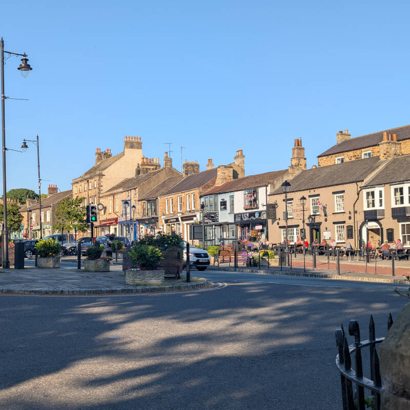
Horse Market and Market Place formed the wide commercial centre of the borough. They were probably not created as two wholly separate streets, but as parts of one long market space beside the castle. There was room for livestock, carts, stalls and crowds, while houses, shops and workshops filled the narrow plots along its sides.
Even the names were once less fixed than they are now. A property was described in 1766 as standing in “Horse Market or Market Street”, which suggests that people did not always draw a sharp boundary between the two. The castle’s eastern ditch and entrance stood beside Horse Market, so trade took place directly beneath the walls of the fortress.
Barnard Castle’s market and fair are securely recorded in 1293, although the market was almost certainly older. The borough had already existed for more than a century, and its broad central streets had clearly been arranged with trading in mind. Market day brought farmers, merchants, livestock, carts and customers into the centre. This was where goods changed hands, tolls were collected, news travelled and neighbours met.
St Mary’s Church was established during the same broad period. Surviving Norman work places it firmly in the 12th century, close to the castle, market and roads leading down towards the Tees. Newgate began beside this important junction and probably developed as a later medieval extension eastwards. Its name likely meant the new street or road, although no surviving document tells us precisely when it was new.
Beyond the medieval town: Marwood and the castle park
Beyond the last houses of the medieval town lay Marwood, a broad landscape of pasture, woodland and castle land. The land itself was there before the Balliols arrived, but the surviving records do not show that a formal park or chase existed before the castle. Its clear place in the story begins after the fortress and borough had been established.
By about 1250, John de Balliol had enclosed part of the surrounding land within his park. In exchange, he granted the burgesses of Barnard Castle—a group of townspeople who held borough rights—a common pasture called Marewood, or Marwood. A later charter confirmed those grazing rights, and in 1410 the burgesses again recorded their right to use the common pasture of Marwood. This surrounding land was therefore not simply somewhere the castle’s lords went hunting. It also mattered to townspeople who needed somewhere to graze their animals.
Marwood and the castle park were closely connected, but they were not necessarily the same thing. The charters distinguish between common pasture in Marwood and land enclosed within the park. The park was the more controlled part of the estate, while the wider landscape also provided grazing and woodland beyond the streets.
The old park boundary remained part of the landscape long after the castle had fallen into decline. An 1884 guide to Barnard Castle described Flatts Wood, written in the guide as “Platts Wood”, as lying within Marwood Chase and the old park belonging to the castle. It recorded that the riverside path followed the line of the old park wall and later reached a section where the wall was still well preserved.
Our Lost Spa Walk through Flatts Wood passes through this historic landscape, and substantial walls can still be seen beside parts of the route. We cannot say that every stone standing today is untouched medieval masonry, because boundaries were repaired and rebuilt over many generations. What we can say is that the walk follows part of the route recorded in the 19th century as the line of the castle’s old park wall.
Down from the market to the river
Barnard Castle stood high above the Tees, but the town depended heavily on the crossing and the river below. The Bank, Bridgegate and Thorngate linked the market and church with Startforth, the mills and the working riverside.
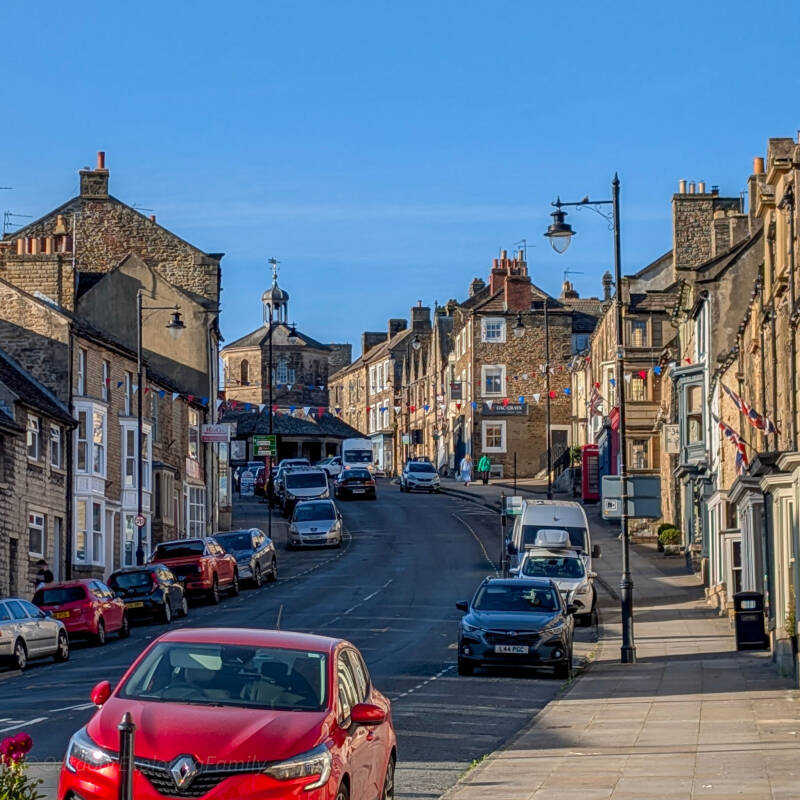
The Bank follows the steep descent from St Mary’s and Market Place. Its name simply describes the slope, but the route is probably medieval. Houses, inns, workshops and shops gradually filled the street, serving people travelling between the river and the market.
Historic street names did not always fit the boundaries we use today. Parts of the present Bank were once described as Thorngate, so old references cannot always be placed neatly onto a modern street map.
Bridgegate led towards the ford and later County Bridge. The route down to the water may therefore be older than many of the buildings standing beside it. As movement across the Tees increased, the road became lined with homes, inns and businesses serving people arriving from Startforth and the Yorkshire side of the river.
Thorngate led down to the working riverside and became closely connected with mills, weaving and later manufacturing. Its original name has not been fully explained, but the reason for the street’s development is much easier to understand. It gave people access to the water and to the work that depended upon it.
Milling had been part of the town for centuries. A confirmation of Barnard Castle’s borough rights in 1410 referred to townspeople grinding their corn in the town mill. The large industrial buildings that survive beside the river are later, however, and their individual histories need to be kept separate.
Thorngate Mill was built during the early 19th century for J. H. S. Pratt and was used for worsted weaving. The building now numbered 24–34 Thorngate was a different mill, built in 1846 for Joshua Monkhouse and Sons to manufacture carpets. Mill Court began as another 19th-century woollen mill and was used by the North of England Chamois Leather Company from 1935 until the early 1980s, producing protective clothing for heavy industry and the Admiralty.
Much of that industrial riverside has disappeared. The surviving mills matter because they remind us that old Barnard Castle was not made up only of attractive houses, churches and market buildings. It was also a place of machinery, weaving, manufacturing, carrying and hard physical work.
A short distance downstream, Egglestone Abbey was founded between 1195 and 1198 for a community of Premonstratensian canons. Its first church was built around 1200, with a larger presbytery and transepts added around the middle of the 13th century. Although the abbey stood outside Barnard Castle, it belonged to the same landscape of roads, estates and river crossings.
After the Dissolution, Egglestone Abbey was granted to Robert Strelley in 1548. He converted parts of the monastic buildings into a country house, with the former refectory becoming a hall. Sir Thomas Robinson sold the estate to John Morritt of Rokeby in 1770, and a later member of the Morritt family placed the ruins in state guardianship in 1925.
County Bridge and the castle’s decline
A permanent bridge eventually replaced or supplemented the old ford, fixing the route between Startforth and Bridgegate. County Bridge is old enough for its exact beginnings to remain uncertain. Parts of it may date from the 14th century, while the surviving records also point to major repair or rebuilding during the late 16th century.
A reset stone marked 1596 is best understood as evidence of work to an existing bridge rather than proof that the entire structure was built in that year. The bridge was repaired again after the great flood of 1771, when work was carried out on its parapets. Historic England’s records for the two sides of the bridge differ slightly in the dates they give, but both show that it has been repaired and altered over a long period.
For generations, County Bridge formed the main southern approach into Barnard Castle. Travellers crossed the Tees before climbing through Bridgegate towards the market. Until 1974, the bridge also crossed the historic boundary between County Durham and the North Riding of Yorkshire. Its narrow roadway makes far more sense when remembered as a crossing built for people, packhorses, livestock and carts rather than modern traffic.
While the town below continued to grow, the castle passed through its last important period as a great residence. It came into the possession of Richard, Duke of Gloucester, in 1471. Richard later became King Richard III and carried out work at the castle while planning a religious college connected with St Mary’s Church. His white-boar emblem survives at both the castle and the church, linking the town with the years when he was its lord.
Richard’s death at the Battle of Bosworth in 1485 ended those plans. The castle remained useful, but its days as one of the great northern residences were fading.
In December 1569, it endured an eleven-day siege during the Rising of the North. The defenders eventually surrendered, and the damage was followed by a steep decline. There was no single day when the castle officially closed. Its buildings gradually stopped being maintained, roofs failed and the fortress lost its purpose. By the early 17th century, it had largely fallen out of use.
Sir Henry Vane acquired the castle in 1625 and removed stone from the ruins for building work at Raby Castle. The town did not decline with the fortress, however. By then, Barnard Castle had established streets, shops, workshops, churches, inns and a market of its own. The castle had helped create the town, but the town no longer depended upon it to survive.
A Georgian town on medieval foundations
By the 17th and 18th centuries, much of the centre was being rebuilt. Older houses were replaced, enlarged or given smarter stone fronts. Regular windows and fashionable doorways appeared along Galgate, Horse Market, Market Place, Newgate and The Bank.
This is when Barnard Castle gained much of the appearance it has today, but the rebuilding did not sweep away the medieval town. The new houses still stood within the old plots, with yards, stables, workshops, stores and gardens behind them. Queen Street, Hall Street, Wycliffe Yard and other back routes developed as the land behind the principal frontages was gradually filled.
The most recognisable addition to the Georgian town appeared in 1747, when Thomas Breaks paid for the octagonal Market Cross in Market Place. We usually call it the Butter Market today, although it served far more purposes than its popular name suggests.
Over the years, the building was used as a market house, courtroom, lock-up, town hall, meeting place and fire station. It did not create the market—the town had been trading there for centuries but it gave the old market space a permanent centre. The dated inscription still records that it was erected at Thomas Breaks’s expense.
Religious life was changing too. A Methodist society had formed by about 1747, first meeting in a house in Galgate and later using the building known as the Hole in the Wall. As the congregation grew, it moved to Broadgates in 1764 or 1765, then to a larger chapel in Wycliffe Yard in 1823.
Hall Street Congregational Church followed in 1836, the Primitive Methodists built a chapel in Newgate in 1887, and Trinity Wesleyan Methodist Church opened at the lower end of Galgate on 30 March 1894. Their changing locations show the congregations moving from houses and tucked-away rooms into large buildings that became part of the townscape.
The Victorians change Barnard Castle
John Wood’s detailed plan of 1827 and the tithe map of 1839 show Barnard Castle shortly before its greatest period of expansion. The built-up town was still concentrated around Galgate, Horse Market, Market Place, Newgate, The Bank, Bridgegate and Thorngate. Behind the houses were yards, gardens and long property boundaries, while open fields began surprisingly close to the centre.
During the following decades, many of those open spaces disappeared beneath streets, homes and public buildings. The Teesdale Poor Law Union was formed in 1837, and a new workhouse was erected at Barnard Castle in 1838. A purpose-built police station followed in Queen Street around 1840, later becoming the magistrates’ courts and public offices. These buildings show how the town was developing new systems of welfare, law and administration beyond its older market streets.
The Witham Testimonial Hall was built in 1845–46 as a home for the Mechanics’ Institute and dispensary. Designed by John and Benjamin Green and paid for by public subscription, it commemorated Henry Witham of Lartington Hall and opened on 27 April 1846.
People could go there to read, attend lectures, learn and receive medical help. A Music Hall was added behind the original building in 1860, bringing concerts, dances, performances, public meetings and later films to Horse Market. A street that had gathered people for medieval markets now gave them new opportunities for education, welfare and entertainment.
Growth also exposed the terrible conditions in some of the poorest parts of town. Between August and October 1849, cholera infected 377 people in Barnard Castle and killed 145. Of those who died, 143 came from the poverty-stricken housing close to the river, where overcrowding, poor drainage and unsafe water allowed the disease to spread with frightening speed.
The outbreak was remembered through the 143 cholera burials carried out at St Mary’s, which is why that number appears in some accounts of the epidemic. It should not, however, be mistaken for the total number of deaths across the town.
As the old churchyard became overcrowded, a new cemetery was established on Victoria Road. Its chapel was completed in 1859 to a design by F. R. N. Haswell. The cemetery stood beyond the old centre and became another sign that Barnard Castle was spreading into what had previously been open land.
Railways, the Bowes Museum and the town beyond Newgate
The railway arrived on 9 July 1856, when the first station opened with the line from Darlington. Journeys that had depended upon horses and coaches became quicker, while traders could move goods more easily and visitors could reach Barnard Castle from much farther away.
A second station opened in 1861, when the railway was extended westwards across Stainmore. These were two different station sites: the first later became a goods depot while the newer station served the through line.
The westward route required impressive engineering. Percy Beck Bridge and Deepdale Viaduct carried the railway across difficult ground beyond the town, while the Tees Valley Railway, opened towards Middleton-in-Teesdale in May 1868, connected Barnard Castle with communities farther up the dale.
For just over a century, the station handled passengers, livestock, parcels, mail and goods. Railway workers and their families became part of the town, and the railway connected Barnard Castle eastwards, westwards and deeper into Teesdale.
At almost the same time, something completely different was rising beyond Newgate. John and Joséphine Bowes began acquiring land for their museum during the 1860s, on fields beyond the old built-up edge of the town.
Joséphine laid the foundation stone on 27 November 1869 in a small private ceremony, and work continued during the following years. The French-style building must have looked extraordinary as it rose beyond the familiar streets and stone houses of Barnard Castle.
John and Joséphine intended the museum for the public and filled it with paintings, furniture and objects collected during their years in France. Neither lived to see it open: Joséphine died in 1874, and John Bowes in 1885.
The Bowes Museum finally opened in June 1892. For centuries, the castle had dominated one end of Barnard Castle; the museum now created another great landmark at the opposite side of town.
Barnard Castle School developed in the same eastern area. Queen Victoria approved the scheme for the North Eastern County School in 1882. It opened temporarily the following year, and pupils moved into the permanent Newgate buildings in 1886. The school chapel was added in 1910–11.
The museum and school changed the character of Newgate. It was no longer simply a road leaving the old town through scattered houses and fields. It had become the approach to two large institutions known far beyond Teesdale.
Loss, protection and the town we inherited
The 20th century brought both loss and protection.
Egglestone Abbey entered state guardianship in 1925, while Lord Barnard placed the castle ruins in state care in 1952. These decisions helped protect two sites that had already lost a great deal of their original fabric.
The railway disappeared almost as quickly as it had arrived. The Stainmore route closed in 1962, and Deepdale Viaduct was dismantled soon afterwards. Passenger services from Barnard Castle ended on 30 November 1964, with the remaining goods traffic stopping on 5 April 1965.
For generations, the station had been where people arrived, left for work or school, met relatives, sent livestock and received goods. Within a few years, most of that railway world had vanished, although bridges, earthworks and parts of the old routes remain in the landscape.
In 1975, the historic centre was designated as the Barnard Castle Conservation Area. That recognised that the town’s importance did not rest only in the castle, Butter Market or Bowes Museum. It also lay in the streets, bridge, river, old property boundaries, back lanes and the relationship between them.
Barnard Castle today still follows the shape created by all those earlier generations. County Bridge and Bridgegate hold the line of the old crossing into town. The Bank climbs towards St Mary’s and Market Place. Horse Market and Market Place retain the space needed by the medieval market, while Galgate may preserve the line of an even earlier settlement. Thorngate follows the working riverside, and Newgate leads towards the Victorian town of the Bowes Museum and Barnard Castle School.
The town did not begin with one grand plan. It grew from a road, a ford and an established community at Startforth. The Balliols added the castle, and a borough developed beside it. The market brought trade, the bridge fixed the crossing, and the mills made use of the river. Georgian builders refaced the medieval streets, while the Victorians added the Witham, railways, schools, public institutions and museum.
That is why Barnard Castle never feels as though it belongs to only one period. The buildings may change as you walk through it, but the old roads keep joining the story together.
Explore more of Barnard Castle’s history
The streets and landmarks mentioned on this page each have their own story. To begin with the building that gave the town its name, read the full history of Barnard Castle, from the Balliol family and Richard III to the siege of 1569 and the castle’s later years as a ruin.
For one of the town’s darker stories, discover the evidence behind Barnard Castle Gallows, the old name Gallowgate and the likely execution ground near the upper end of Galgate.
On The Bank, you can explore the remarkable history of Blagraves House, including the Blagrave family, the building’s surviving 17th-century features and the stories that have gathered around it over the years.
Nearby, read about the Hole in the Wall, where Barnard Castle’s early Methodist society met before moving to larger chapels as the congregation grew.
You can also discover the history of the old police station and magistrates’ courts in Queen Street, following the town’s changing approach to law, policing and public administration.
To find more historic buildings, streets and stories in one place, return to the Barnard Castle History and Heritage Hub. For practical help planning a visit, including walks, attractions, parking and places to explore, use our Barnard Castle Town Guide.